You've reached the Virginia Cooperative Extension Newsletter Archive. These files cover more than ten years of newsletters posted on our old website (through April/May 2009), and are provided for historical purposes only. As such, they may contain out-of-date references and broken links.
To see our latest newsletters and current information, visit our website at http://www.ext.vt.edu/news/.
Newsletter Archive index: http://sites.ext.vt.edu/newsletter-archive/
New Crop Insurance Option for Virginia Pasture and Hay Producers Using the Pasture Rangeland and Forage Vegetation Index1
Farm Business Management Update, December 2008 - January 2009
By Scott Reiter (jreiter@vt.edu), Extension Agent, Crop and Soil Science, Prince George County

1The signup date for this product has passed (November 30, 2008); however, this is a new policy for Virginia and was just recently released. This article will allow instead farmers time to do their homework before 2009 signup.
This fall a new crop insurance product was made available for forage producers in all Virginia counties. The Vegetation Index has been a pilot program through the Risk Management Agency for a couple of years in other states. This product is intended to be a tool to be used in managing production risks on Virginias grazing and hay lands.
The Vegetation Index uses Normalized Difference Vegetation Index (NDVI) data from the U.S. Geological Survey Earth Resources Observation and Science data center. The NDVI is a measure of vegetation greenness taken by satellite image. NDVI correlates to forage condition and productive capacity in approximately 4.8 x 4.8 mile grids. In general, the healthier the plants are in a given grid, the higher the NDVI value. The unique part of this insurance product is that it does not require a producer to keep or provide production records on hay or pasture. Losses calculated using the Vegetation Index are indemnified based on the deviation from normal within the grid and index interval(s) selected. Your individual farm production has no impact on your insurance payment and payments are strictly based on how green your grid area is from the NDVI satellite image.
The producer is asked to make several choices when insuring grazing land or hay land production, including coverage level, index intervals, productivity factor, and number of acres.
A coverage level is selected from 70-90% in increments of 5%. This is used to calculate your forage value per acre and to determine your trigger index value where an indemnity payment would be made. Premiums and potential indemnities increase as your coverage level increases.
With this plan, producers may select one or more 3-month time period(s) that represent a producers forage species production. These time periods are called index intervals. The intervals are: I = April-June, II = July-September, III = October-December and IV = January- March. Producers are not required to insure all acres, but cannot exceed the total number of grazing or haying acres they operate. This allows a producer to insure only those acres that are important to his or her grazing program or hay operation. Producers can purchase insurance in one or all index intervals each year.
Producers select a Productivity Factor, a value between 60 and 150 percent of the County Base Value. This is used to match the amount of protection to the value of forage that best represents the specific grazing or hay operation, as well as the productive capacity of the land. An alfalfa producer may select a productivity level over 100% whereas a low management fescue field may be valued at less than 100%.
Producers work with their crop insurance agents to view the map and index grids for their area, and assign acreage to one or more grids based on the location and use of the acreage that is to be insured. Producers also do not have to file a claim to receive indemnity payments. Your insurance company will monitor the final Vegetation Index and send you an indemnity payment if one is due. Producers can monitor the Vegetation Index by going to the website http://prfvi-rma-map.tamu.edu/default.aspx.
Only established perennial forages can be insured under the Vegetation Index. Annual planted forages like crabgrass, millet, or rye are not eligible. Newly seeded forages must be planted by July 1 in the year before insurance coverage is purchased. Perennial forages can be over seeded with annuals but the base forage must be a perennial species.
Livestock producers must either purchase Vegetation Index crop insurance or pay the Non- Insured Crop Disaster Assistance Program (NAP) fee for grazing and hay land to be eligible for USDA disaster programs such as Emergency Assistance for Livestock, Honey Bees, and Farm- Raised Fish (ELAP) and Livestock Forage Disaster Program (LFP). This is a new requirement in the 2008 Farm Bill.
Crop farmers must insure their hay acreage or pay the NAP fee on hay land to be eligible for disaster payments under the Supplemental Revenue Assurance Program (SURE). Again this is a new requirement under the 2008 Farm Bill. The acreage reporting and sales closing date for Vegetation Index insurance or NAP is November 30, 2008. Since the deadline has passed, producers should contact their crop insurance agent to get detailed information about the Pasture, Rangeland, and Forage Vegetation Index for a decision next year. Your local Farm Service Agency can provide additional information on NAP and CAT coverage for pasture, hay, and row crops.
The Map Driven Weather Grid Id Locator for Pasture, Rangeland, Forage Vegetation Index Insurance Program website contains an interactive map that allows you to search for your farm and determine your grid area location (see Figure 1). The corresponding grid number is then used to calculate premiums and review past NDVI index values. The website link is: http://prfvi-rma-map.tamu.edu/default.aspx.
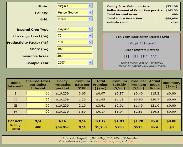
The base values for grazing land and hay land coverage are set at the county level. For example, the base production value for Prince George County grazing land is $36.70 per acre and hay land is $231.98 per acre. Premiums are based on a percentage of the base production value, coverage level, and productivity factor. The following chart (Figure 2) shows the premiums and potential payments for 70% coverage and 100% productivity for hay land in Grid # 96937 in Prince George, VA.
Figure 1: Example grid area
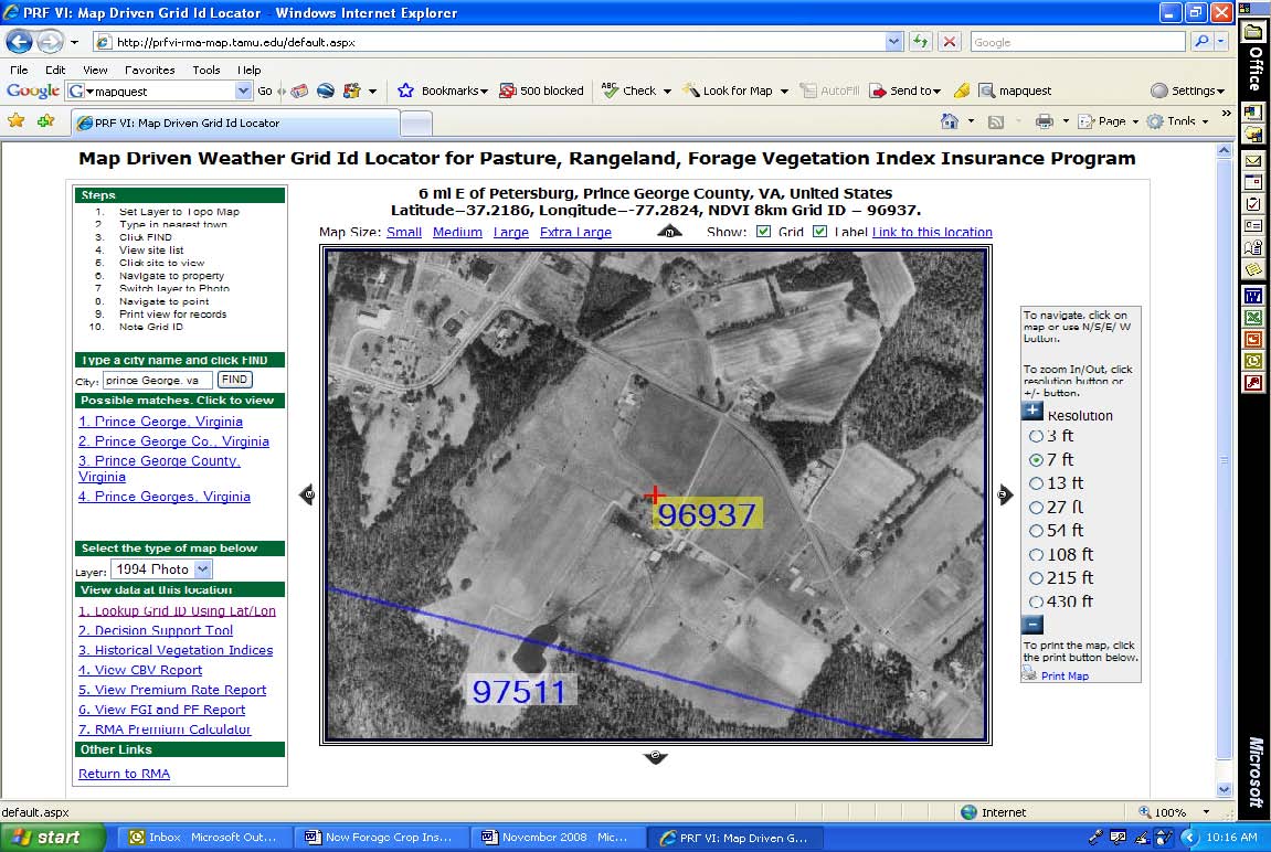
Figure 2: Farm Example Prince Edward County
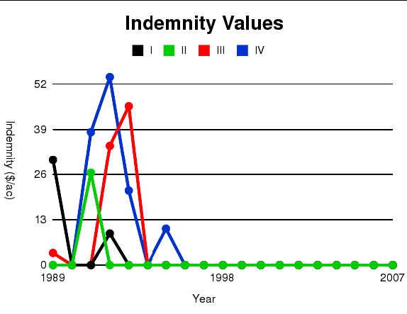
You can also view historical Vegetation Indices or potential indemnity values since 1989 at this same web site. This potential indemnity graph (Figure 3) is for Grid # 96937 based on 70% coverage and 100% crop productivity in Prince George County.
Figure 3: Farm Example Price Edward County Vegetation Indices